
LiDAR Technology: Revolutionizing 3D Mapping, Scanning, and Additive Manufacturing
LiDAR, an acronym for Light Detection and Ranging or Laser Imaging Detection and Ranging, represents a groundbreaking remote sensing technology capable of generating highly accurate three-dimensional models of environments and objects. Its unparalleled ability to collect volumetric data with exceptional precision has transformed how we map and understand the world around us. This innovative technology finds critical applications across diverse sectors, including archaeology, construction, civil engineering, and urban planning. Furthermore, when combined with advanced 3D printing solutions, LiDAR becomes an invaluable tool, enhancing manufacturing processes and quality control. Its inherent speed, reliability, and precision also establish it as an indispensable component in the rapidly advancing field of autonomous vehicles, providing real-time environmental awareness.
The origins of LiDAR trace back to the 1960s, initially developed for large-scale land mapping. Over the decades, this technology has undergone profound evolution, significantly benefiting from the integration of Global Positioning System (GPS) and Inertial Navigation System (INS) technologies. These additions provided crucial spatial and orientation data, elevating LiDAR’s accuracy and utility. Today, its versatility allows it to be seamlessly embedded in a wide range of devices, from sophisticated 3D scanners used by professionals to cutting-edge 3D printers, where it dramatically improves performance, accuracy, and overall operational efficiency across various applications.

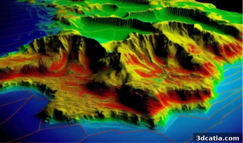
A 3D model generated from LiDAR data (Photo credits: ResearchGate – Kenji Omasa)
Understanding LiDAR: How Light Pulses Create 3D Worlds
At its core, LiDAR is a sophisticated remote sensing technology that harnesses the power of laser pulses to precisely measure distances between the sensor and various objects or surfaces. This fundamental principle allows for the accurate reconstruction of intricate three-dimensional models. A typical LiDAR system comprises several key components: a laser scanner responsible for emitting light pulses, a highly sensitive LiDAR sensor that detects the reflected pulses, and a powerful processor tasked with interpreting the vast amounts of collected data. The operational process begins with the laser scanner emitting millions of focused light pulses every second at a specific wavelength towards the surfaces designated for analysis. As these light pulses strike objects within the environment, they are reflected back towards the LiDAR sensor.
Upon reflection, the sensor captures these returning pulses and converts them into individual data points. The aggregation of these countless points forms what is known as a “point cloud” – a comprehensive digital representation containing all the spatial information gathered during the scan. The system’s processor then meticulously analyzes this data, primarily by measuring the “time of flight” (ToF). ToF refers to the incredibly brief duration it takes for each laser pulse to travel from the emitter, strike an object, and return to the sensor. By precisely calculating this time for each pulse, alongside the horizontal and vertical emission angles of the laser, the LiDAR system can accurately compute the three-dimensional coordinates (X, Y, and Z) for every single point in the point cloud. The remarkable density and unparalleled precision of these generated points enable the creation of extraordinarily detailed and accurate 3D representations of any scanned environment or object, making it an indispensable tool for applications demanding the highest levels of spatial fidelity.
LiDAR vs. Photogrammetry: A Comparative Analysis of 3D Mapping Technologies
While both LiDAR and photogrammetry share the overarching goal of detecting and three-dimensionally mapping objects or environments, they achieve this objective through fundamentally different operational principles and technologies. Photogrammetry is a technique that reconstructs 3D models from a series of overlapping two-dimensional photographs captured from various angles. It intelligently extracts 2D visual data from these images and mathematically converts it into a comprehensive 3D digital model. In contrast, LiDAR employs a laser beam to directly measure distances, generating a dense point cloud that serves as the foundation for constructing a precise 3D model. In this regard, LiDAR’s direct measurement approach bears a closer resemblance to a structured light 3D scanner than to the image-based methodology of photogrammetry.
Photogrammetry relies heavily on conventional cameras and the presence of sufficient natural or artificial light to conduct its surveys. While capable of delivering remarkably detailed visual results, the accuracy and fidelity of the data it obtains are critically dependent on the ambient lighting conditions at the time of image capture. Challenges arise with difficult surfaces such as those that are highly reflective or transparent, which can introduce distortions or inaccuracies into the captured data. Moreover, the ultimate quality of the 3D model generated through photogrammetry is influenced by factors like the resolution of the input images and the number and distribution of viewpoints utilized during the photographic process, often requiring careful planning and execution to achieve optimal outcomes.
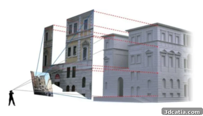
Image showing how photogrammetry works. (Photo credit: Microgeo)
LiDAR distinguishes itself with its exceptional accuracy, particularly when confronted with complex geometries and intricate surfaces, consistently performing well even in challenging low-light and adverse visibility conditions, where photogrammetry would struggle significantly. While photogrammetry is generally better suited for capturing well-lit, visually distinct objects or environments, LiDAR truly excels in creating highly detailed and spatially accurate topographical maps of extensive territories, irrespective of illumination. This makes LiDAR the preferred choice for applications requiring precise measurements over vast areas, such as forestry, urban planning, and infrastructure development.
From a cost perspective, photogrammetry typically presents a more economical solution than LiDAR, primarily because it leverages readily available standard cameras and photography equipment. However, this cost-effectiveness often comes with a trade-off: the resulting 3D models may not always achieve the highest levels of accuracy and frequently necessitate extensive additional post-processing work to refine and correct imperfections. Conversely, the significantly more accurate 3D models generated by LiDAR systems generally require minimal to no post-processing adjustments, saving considerable time and labor in the long run. The initial higher investment in LiDAR technology is often justified by the superior data quality and reduced downstream effort.
In summary, photogrammetry offers a simpler and more budget-friendly approach, but its precision can be compromised by environmental conditions and relies on visual input. LiDAR, while demanding a higher initial investment, delivers unmatched precision and reliability, independent of external lighting. An alternative to both, for smaller-scale, highly detailed work, is traditional 3D scanning. These systems are often more affordable than professional LiDAR solutions and capable of capturing exceptionally fine details. However, they are generally slower and less suitable for comprehensive coverage of expansive areas when compared to the speed and range of LiDAR technologies, highlighting that the choice of technology depends heavily on the specific application’s requirements for scale, precision, and budget.
Exploring LiDAR Scanner Types and Their Diverse Applications
LiDAR scanners are broadly categorized into two primary types based on their deployment: terrestrial laser scanners (TLS), which operate from ground-based platforms, and airborne laser scanners (ALS), designed to be installed on aerial vehicles. Terrestrial laser scanners can be further subdivided into static and mobile configurations. Static scanners are typically mounted on fixed supports, such as tripods or permanent structures, enabling them to produce extremely high-precision surveys of stationary objects like buildings, historical monuments, complex industrial facilities, or archaeological sites. These are ideal for detailed structural analysis and digital preservation. In contrast, mobile scanners (MLS) are integrated into vehicles, ranging from cars and trucks to specialized machinery. MLS are particularly well-suited for dynamic, large-scale mapping projects, such as surveying city streets, infrastructure corridors, or vast construction sites at speed, capturing detailed data as the vehicle moves. Moreover, in specialized autonomous devices like robotic vacuum cleaners, compact LiDAR systems are mounted on rotating discs, allowing the laser to perform a continuous 360° scan of their immediate surroundings for navigation and obstacle avoidance.
Airborne LiDAR scanners (ALS) are deployed on aerial platforms, commonly airplanes or helicopters, and increasingly, on unmanned aerial vehicles (UAVs or drones). These systems measure the precise time of flight of laser pulses emitted from the aircraft, calculating the exact distance between the sensor and the ground below. This allows for the rapid acquisition of extensive topographic data, crucial for large-scale land mapping, environmental monitoring, and disaster management. When mounted on drones equipped with advanced mapping and navigation systems, ALS offers unprecedented flexibility for surveying difficult-to-access areas or conducting high-resolution inspections.
The versatility of LiDAR extends to a multitude of applications across various industries. In the realm of smart home technology, LiDAR is frequently integrated into robot vacuum cleaners, enabling them to accurately map entire rooms, identify cleaned areas, and plan efficient cleaning routes, significantly enhancing their autonomy and effectiveness. For self-driving vehicles, LiDAR is a cornerstone technology, providing crucial real-time spatial awareness that ensures driving precision, enhances safety through superior obstacle detection, and facilitates advanced navigation capabilities. On consumer devices like iPhones and iPads, integrated LiDAR sensors significantly improve camera autofocus performance, enhance depth perception for photography, and make augmented reality (AR) applications far more immersive and realistic by accurately mapping the user’s environment. Beyond consumer tech, LiDAR is employed in Google’s autonomous mapping vehicles to survey vast expanses of terrain, generating the rich, high-fidelity data that underpins services like Google Earth. Furthermore, the presence of LiDAR sensors in modern mobile devices has empowered user-friendly software such as Polycam, allowing individuals to quickly and accurately capture detailed 3D models of environments, rooms, and floors with remarkable ease and precision, democratizing access to professional-grade spatial data capture.
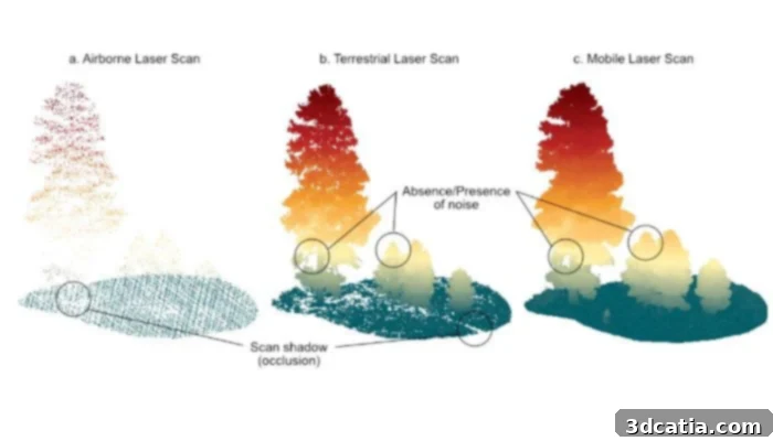
Detection differences between ALS, TLS and MLS. (Photo credits: MDPI)
LiDAR Integration in 3D Printers and Scanners: Enhancing Performance
While a built-in LiDAR sensor is not yet a universal standard feature in most commercial 3D printers, the trend towards its integration is rapidly gaining momentum, with numerous innovative solutions and experimental projects actively exploring its potential to revolutionize the additive manufacturing process. A notable example comes from the Chinese manufacturer Creality, which introduced the K1 MAX 3D printer. This machine is equipped with advanced LiDAR scanners specifically designed to detect and identify potential anomalies or inconsistencies on the printing plate even before a print begins. More impressively, this intelligent system continuously monitors not only the crucial first layer but also subsequent layers throughout the printing process, ensuring optimal print quality, preventing common errors like warping or delamination, and guaranteeing the flawless creation of complex models. Similarly, Bambu Lab leverages LiDAR technology in its acclaimed Bambu Lab X1 series. Here, the LiDAR system plays a critical role in dynamically adjusting the pressure and flow rate of the extruder, ensuring consistent material extrusion and superior print surface finish, which is paramount for achieving high-fidelity prints with intricate details. For specialized industrial applications or scenarios where existing commercial solutions fall short, LiDAR sensors can be custom-integrated into bespoke projects or hybrid manufacturing setups, offering unparalleled control and precision. The investment for such integrated solutions starts from approximately €700, as seen with the Creality K1 MAX, and can exceed €1,000 for advanced models like the Bambu Lab X1 series, reflecting the enhanced capabilities they offer.
In the realm of dedicated 3D scanners, LiDAR technology has become a cornerstone, with a variety of advanced devices available on the market catering to different needs and budgets. For instance, the LiDAR 3D FJD Trion P1 is a versatile solution highly regarded for its capability in both indoor and outdoor mapping, offering flexibility across a broad spectrum of surveying tasks. Another high-performance example is the Artec Ray II, a professional-grade scanner capable of meticulously scanning expansive areas and large-scale objects from distances up to 130 meters, making it ideal for industrial inspections, heritage preservation, and architectural documentation. These cutting-edge scanners can be procured through various channels, including major online retail platforms such as Amazon, or directly from the manufacturers’ official websites. The pricing for LiDAR scanners varies dramatically depending on their intended application, ranging from highly affordable basic sensors, which can cost around $45 for entry-level use, to sophisticated professional solutions like the Artec Ray II, which can command prices well over $100,000, underscoring the vast array of options available to meet specific precision, range, and operational demands.
The Advantages and Challenges of Integrating LiDAR in 3D Printing
The integration of LiDAR technology in 3D printing offers a compelling suite of advantages that can significantly elevate the additive manufacturing process. Foremost among these is the unparalleled precision that LiDAR can achieve. Its ability to capture incredibly accurate spatial data translates directly into higher fidelity 3D prints, ensuring that physical objects precisely match their digital designs with minimal deviation. Additionally, one of the most transformative benefits of LiDAR is the provision of real-time feedback during data collection and, critically, throughout the printing process. This immediate flow of information allows for instantaneous adjustments to production parameters, enabling operators or automated systems to correct issues as they arise, optimize material deposition, and streamline the entire workflow. This real-time control not only drastically improves the final print quality by reducing errors and inconsistencies but also minimizes material waste and accelerates iteration cycles, ultimately leading to more efficient and cost-effective manufacturing.
Despite its numerous advantages, the widespread integration of LiDAR technology, especially in 3D printing, is not without its challenges. One of the most significant barriers remains its cost, which can be substantial, particularly for professional-grade, high-performance solutions. This high initial investment can deter smaller businesses or individual users from adopting the technology. Furthermore, the sheer density of data contained within LiDAR-generated point clouds presents another considerable hurdle. Processing this immense volume of spatial information, especially when integrating it into existing Computer-Aided Design (CAD) software for 3D printing workflows, can demand significant computational power and specialized software. This can lead to bottlenecks in data processing and require robust hardware infrastructure, adding to the overall cost and complexity. While LiDAR sensors are increasingly integrated into popular mobile devices like iPhones and iPads, their performance, in terms of range, accuracy, and data density, is often inferior to that of dedicated, professional systems such as terrestrial laser scanners (TLS) or mobile LiDAR units. This performance gap means that consumer-grade LiDAR may not meet the stringent precision requirements for high-end industrial 3D printing applications. Lastly, environmental factors, although less impactful than for photogrammetry, can still affect LiDAR performance; for example, certain wavelengths can be attenuated by heavy fog, rain, or dust, potentially reducing data quality in challenging outdoor conditions.
What are your thoughts on LiDAR’s impact on technology? Let us know in the comments below or connect with us on our LinkedIn or Facebook pages! Don’t forget to sign up for our free weekly Newsletter to get the latest 3D printing news delivered straight to your inbox. You can also explore all our videos and interviews on our YouTube channel for more insights.
*Cover Photo Credit: American Oceans